

LandLens for Google Maps & Earth

Overview
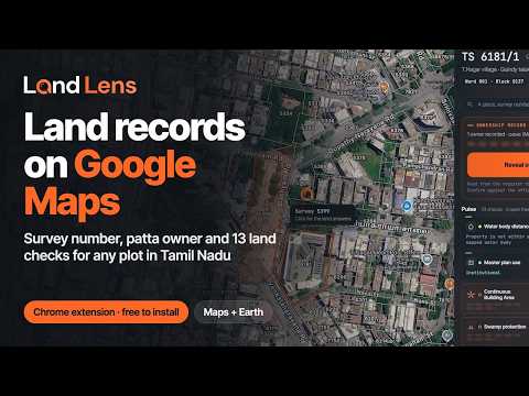
Tamil Nadu land records on Google Maps: survey number, FMB boundary, patta owner, guideline value and 13 land checks for any plot.
LandLens for Google Maps & Earth shows Tamil Nadu land records on Google Maps and Google Earth. Zoom in on any place in Tamil Nadu and the survey boundaries (FMB) appear over the satellite view, with the survey number under your pointer. Click a plot to see its land record without leaving the map. What you see for a plot Survey number with its register (TS, RS or SF), sub-division, village, taluk and district Recorded extent, land type, ward and block for town survey plots, and ULPIN Patta owner names from the revenue register, in Tamil and English (1 credit) Guideline value per sq ft from the registration department Pulse: 13 land checks, including water body distance, flood zone, master plan land use, coastal regulation (CRZ), aquifer zone, road widening, and the temple (HR&CE) and Waqf land registers Neighbouring plots, deep checks by category, full property verification with encumbrance, and a legal opinion quote Find any plot Search by place, survey number, coordinates or map link By record: pick district, taluk and village as written on the patta, then the survey number Draw or trace a region, select several plots at once, or import KML, KMZ, GeoJSON or GPX 33 map layers: water bodies, flood extents, coastal zones, heritage sites, airports, master plans and more The free land record inside Google's own place panel LandLens One, the land assistant, in Chrome's side panel with your plot attached Questions What does LandLens for Google Maps & Earth do? It draws Tamil Nadu survey boundaries on Google Maps and Google Earth and shows the land record, owners and checks for any plot you click. Which areas does it cover? Tamil Nadu, rural and town survey plots. Outside Tamil Nadu it stays out of the way. Is it free? Boundaries, survey numbers, the basic land record and three checks are free. Owner names and deeper checks use LandLens credits, and every price is shown before anything is charged. Do I need an account? Yes, a LandLens account on verified.realestate. Does it work on Google Earth? Yes, including tilted 3D views. Built by Verified.RealEstate (LandLens). Land records are read from the Tamil Nadu government registers; confirm against the official extract before acting. Not affiliated with or endorsed by Google.
5 out of 52 ratings
Details
- Version0.1.5
- UpdatedOctober 12, 2026
- FeaturesOffers in-app purchases
- Size307KiB
- LanguagesEnglish
- DeveloperVignesh SelvarajWebsite
No: 8/20 Singara Garden 3rd street Old washermenpet Chennai, Tamil Nadu 600021 INEmail
hello@verified.realestatePhone
+91 72996 09996 - TraderThis developer has identified itself as a trader per the definition from the European Union and committed to only offer products or services that comply with EU laws.
Privacy

LandLens for Google Maps & Earth has disclosed the following information regarding the collection and usage of your data. More detailed information can be found in the developer's privacy policy.
LandLens for Google Maps & Earth handles the following:
This developer declares that your data is
- Not being sold to third parties, outside of the approved use cases
- Not being used or transferred for purposes that are unrelated to the item's core functionality
- Not being used or transferred to determine creditworthiness or for lending purposes
Support
For help with questions, suggestions, or problems, please open this page on your desktop browser