


Genel bakış
Convert Geographical Coordinates among different projections and use them to create KML files.
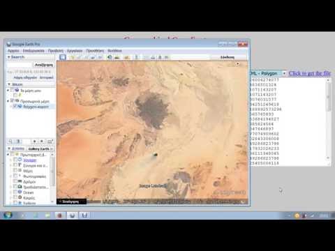
Convert Geographical Coordinates among popular and widely used projections and then use them to create KML files of points, lines or polygons. Simply paste a list of coordinates in a textarea of the app then choose a projection and hit the Convert button. The converted and the original coordinates may be exported in KML files as multipoint datasets, as linear features or as polygons. Use this app in conjunction with "WMS Map Viewer On Line" and get a powerful set of geoprocessing web apps that run fast and they are accessible from anywhere.
5 üzerinden 0Puan yok
Ayrıntılar
- Sürüm1.1
- Güncellenme tarihi:12 Eylül 2017
- Boyut11.66KiB
- DillerEnglish
- GeliştiriciWeb sitesi
E-posta
rodispantelis@gmail.com - Tacir olmayanBu yayıncı kendisini tacir olarak tanımlamamış. Avrupa Birliği'ndeki tüketiciler açısından bakıldığında, bu geliştiriciyle yapmış olduğunuz sözleşmelerde tüketici haklarının geçerli olmadığını lütfen unutmayın.
Gizlilik

Uzantıları yönetin ve kuruluşunuzda nasıl kullanıldıklarını öğrenin.
Geliştirici, verilerinizin toplanması ve kullanılmasıyla ilgili herhangi bir bilgi sağlamadı.
Destek
Sorular, öneriler veya sorunlarla ilgili yardım için lütfen bu sayfayı masaüstü tarayıcınızda açın