


Overview
Convert Geographical Coordinates among different projections and use them to create KML files.
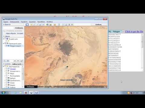
Convert Geographical Coordinates among popular and widely used projections and then use them to create KML files of points, lines or polygons. Simply paste a list of coordinates in a textarea of the app then choose a projection and hit the Convert button. The converted and the original coordinates may be exported in KML files as multipoint datasets, as linear features or as polygons. Use this app in conjunction with "WMS Map Viewer On Line" and get a powerful set of geoprocessing web apps that run fast and they are accessible from anywhere.
0 out of 5No ratings
Details
- Version1.1
- UpdatedSeptember 12, 2017
- Size11.66KiB
- LanguagesEnglish
- DeveloperWebsite
Email
rodispantelis@gmail.com - Non-traderThis developer has not identified itself as a trader. For consumers in the European Union, please note that consumer rights do not apply to contracts between you and this developer.
Privacy

Manage extensions and learn how they're being used in your organization
The developer has not provided any information about the collection or usage of your data.
Support
For help with questions, suggestions, or problems, please open this page on your desktop browser